Part 1 - Two years after the 2017 Kenow Wildfire at Waterton Lakes National Park
A three day, 47km solo backcountry trip in Waterton Lakes National Park to examine the area’s recovery from the 2017 Kenow Wildfire.
My route
I have never responded to an emergency or disaster as a first responder……but I have worked in Government of Alberta‘s Provincial Operation Centre during many events. One event I worked was the 2017 Kenow Fire in Wateron Lakes National Park. My viewpoint was from the chair of the Operations Section Chief, 700 KM away in Edmonton.
The main goal of my trip was to gain perspective. I wanted to do this because disaster and emergency management is complex, it requires a perspective from many angles.
This is not a scientific research study and I am not a wildfire expert. Much of what I have learned about forest fire recovery was self study, mostly from this guide produced by Firewise Wyoming.
My Route
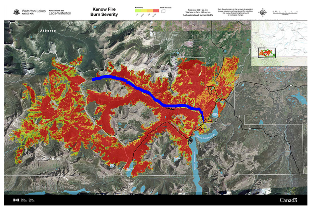
My return trip, as shown on the map below, started at the Red Rock Parkway entrance (just off Highway 5) where I hiked west to Snowshoe Campground.
The route was a mixture of pavement and forested trail. Due to the fire, Red Rock Parkway was closed to vehicles but open to bicycle and pedestrian traffic.
What would normally have been a 20 minute drive was a four hour hike on the small two lane road. At the end of the road was the start of a two hour 8.6 KM hike through the Waterton forest to the campground.
Burn severity map with my route in blue.
2017 Wildfire Burn Severity
The Hike
As I walked the Red Rock Parkway wildflowers bloomed against the mostly blue sky and the mountains, with a hint of burnt trees.
Natural Resources Canada defines a crown fire as the most intense and dangerous type of wildfire. I like the follwing chart by Peter F. Kolb that explains how to assess trees after a wildfire. His paper on Tree and Forest Restoration Following Wildfire can be found here.
Assessing a tree after a wildfire — Peter F. Kolb
As I approached the scorched tress they were either 90 per cent or 100 per cent scorched. Crown consumed trees became more prevalent as I moved west.
As I approached the bend in the road a Black Bear was on the ridge to my right, about 75 meters away. I scared it off with a few hand claps. It served as an early reminder to stay bear aware.
Edge of the burnt treeline and a bear (not visible) just after the corner in the foreground
The Small Things
More damage became noticeable, such as…….burnt guard rail posts……..scorched signs……… and melted highway markers.
Seeing them made me think about how much work goes into recovering from a disaster. I often hear about the big things like rebuilding homes and bridges but rarely hear about the small things like replacing burnt road sign posts and highway guards.
It made me think about the amount of time and planning it must take to survey, order, and replace the small things before an area can be made safe again.
From a high point along Red Rock Parkway, looking southwest.
When I arrived at Red Rock Canyon I bumped into a Parks Canada staff member who was mountain biking on their day off.
She mentioned that a lot of the locals like the parkway closed to vehicles. The serenity of being able to ride a bicycle on a road where vehicles are normally bumper to bumper is a different experience for those that live in the area. The goal of Parks Canada is to reopen all roads to vehicle traffic within the next couple of years.
Snowshoe Trail
After a 45 minute break, that included soaking my feet in a stream and eating lunch, I stared my hike along Snowshoe Trail. A lot of the area was made up of charred trees……..hydrophobic soil……..burnt stumps…….and lots of new growth. The below was taken from the Firewise Wyoming Wildfire Recovery Guide. It’s a good chart that shows the various levels of soil and how wildfires can strip the land of the soil surface and wettable soil.
Taken from Firewise Wyoming- Recovery After a Wildfire
“From a distance, every charred tree stump that stood 3–4 feet started to look like the back of a Black Bear which made for an unsettling experience.”
Me standing on charred deadfall
There is lots of area where undergrowth is taking root. There is also many spots where the land is bare and water repellent; which I tested by pouring water on the soil.
For the few spots that I stopped at, water would take anywhere from 20 to 40 seconds to penetrate the soil and lots beaded down the slope. From what I understand, in most cases, water repellent soil will weaken the more it rains. Rain will carry surface soil from higher elevations (if available) and the black char coming off of burnt trees adds to the regrowth.
In Part 2, I detail the exposed tree root networks that I came across……describe how new water courses may be developing in the park…..and I’ll mention some of the impacts to local businesses.
For a bit of a different view, visit my Polarsteps trip page.
Brad Ison is a disaster management professional, All Hazards Coach, and owner of Hazardscape Management Inc.


